Monday, November 3rd
ms Zuiderdam
Sunfarer Day 7
Partial Transit of the Panama Canal
Enter: 5:00 AM
Exit: 1:00 PM
Colon, Panama
Arrive: 3:00 PM
Depart: 6:00 PM
Partly Cloudy - 83 Degrees
We first transited the Panama Canal in 2000 on a Millennium cruise from Acapulco to Miami on the ms Maasdam. It was easily among the top ten highlights of our time at sea. The Panama Canal, one of the Seven Wonders of the Modern World, is a miracle of human achievement, an engineering marvel, and maybe the greatest story of man over nature ever told. We read David McCullough's epic accounting of the digging of the canal, The Path Between the Seas, on that trip. If you ever want to know the long story, this is your source.
The short story is this: The French, fresh off their success building the Suez Canal, began construction of the Panama Canal to join the Atlantic and Pacific Oceans at sea level in 1881. They were defeated by engineering challenges and inhospitable conditions the likes of which they had never seen and could scarcely have imagined, including torrential rains eight months of the year, dense jungles full of obstacles and fraught with danger, landslides that set back their work time and again, industrial accidents and tropical diseases like yellow fever and malaria that decimated their ranks. The original contractor went bankrupt in 1889 after sinking $287,000,000 into the project and losing 22,000 men. A second French attempt never made it out of the ground. This is all that's left of the failed French canal.

The United States took over in 1904 in what was part purchase and part coup. President Theodore Roosevelt orchestrated the takeover in Rough Rider fashion. "I took the Isthmus, started the canal and then left Congress not to debate the canal, but to debate me." The Americans rebuilt the infrastructure, replaced dilapidated equipment, appointed a chief sanitation officer to minimize the spread of deadly diseases, and abandoned the sea-level canal in favor of a lock system to bridge the Continental Divide. It still wasn't easy. Excavation totaled more than 200,000,000 cubic yards of earth. After another $500,000,000 and the loss of 5,600 more lives, The Panama Canal finally opened to vessel traffic on August 15th, 1914. It has revolutionized global shipping, transiting 14,000 ships a year, nearly a million overall, and shaving thousands of nautical miles from transoceanic travel. The Canal Zone remained under US control until 1999 when it was ceded back to the Panamanians.

The canal does not cross the Isthmus of Panama from East to West as you would think. It actually runs North (NW) to South (SE) from the Caribbean Sea and the Atlantic Ocean in the North to the Gulf of Panama and the Pacific Ocean in the South.
 |
| Copyright Getty Images |
There are three sets of locks, fed entirely by gravity, that raise ships up from sea level to cross at the narrowest point between the Americas, and then lower them back down to sea level on the other side. A ship going Southbound, from Atlantic to Pacific, will enter the canal in Limon Bay at Colon. The Gatun Locks lift the ship a total of 85 feet in three stages, like steps in a staircase, up to the level of Gatun Lake. The ship will then proceed to the Southeast through the lake to the Culebra (Gaillard) Cut. This eight mile gorge, blasted through the highest point on the isthmus and across the Continental Divide, is smooth sailing now, but it was the most ambitious and treacherous part of the dig. Once through the cut, the Pedro Miguel Locks lower the ship 31 feet in a single stage down to the level of Miraflores Lake. In the final leg of the journey, the Miraflores Locks lower the ship 54 feet in two stages back down to the level of the Pacific, and the ship will exit the canal in Balboa Harbor at Panama City. The entire 50 mile trip takes about 11 hours, but ships often have to anchor in Gatun Lake to wait for clearance to proceed. There are two lanes through the canal, the cut is too narrow for ships to pass. Traffic in both lanes moves Northbound from the Pacific and Southbound from the Atlantic in the morning, Northbound to the Atlantic and Southbound to the Pacific in the afternoon.
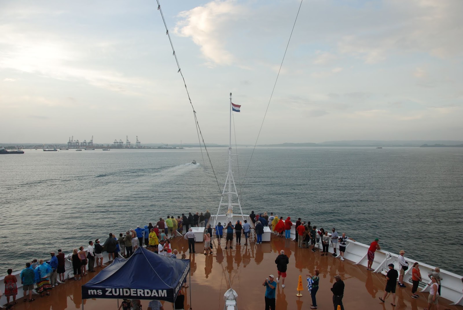
Our visit today, in honor of the 100th anniversary of the opening of the canal, was just a partial transit. We only went as far as Gatun Lake, but the thrill and fascination were just the same as our full transit going the other direction in 2000. With just one set of locks to transit, we didn't want to miss a thing. We were out on deck at 5:00 this morning for first light and first sight.
The canal pilot has boarded the ship and taken the helm. The tug boats are in position alongside fore and aft.
Zuiderdam navigates into Limon Bay with the Port of Cristobal in the distance.
The shipping channel narrows on approach to the canal.
Gatun Locks, dead ahead.
As Zuiderdam enters the left channel of the Gatun Locks, MSC Kim is ahead of her in the first lock chamber, almost 30 feet higher in the water.
MSC Kim is now in the second lock with the gates closed behind her and the first lock is clear. 2,700,000 gallons of water flow through culverts in the lock walls from the first lock into the entrance channel and Limon Bay.
With the water level equalized between the first lock and the entrance channel, Zuiderdam can proceed into the first lock.
MSC Kim is now in the third lock with the gates closed behind her and the second lock is clear. Zuiderdam is now in the first lock with the gates closed behind her. 2,700,000 gallons of water flow through culverts in the lock walls from the second lock into the first, the rising tide that lifts the ship.
Zuiderdam has climbed the first step. With the water level equalized between the second lock and the first, she can proceed into the second lock.
MSC Kim is now emerging from the canal into Gatun Lake and the third lock is clear. Zuiderdam is now in the second lock with the gates closed behind her. 2,700,000 gallons of water flow through culverts in the lock walls from the third lock into the second, the rising tide that lifts the ship.
Zuiderdam has climbed the second step. With the water level equalized between the third lock and the second, she can proceed into the third lock.
Zuiderdam is now in the third lock with the gates closed behind her. 2,700,000 gallons of water flow through culverts in the lock walls from Gatun Lake into the third lock, the rising tide that lifts the ship.
Zuiderdam has climbed the third step. With the water level equalized between Gatun Lake and the third lock, she can proceed into Gatun Lake.
As Zuiderdam emerges from the Gatun Locks, now 85 feet above sea level, the next ships to transit the locks wait behind her.
The ship's photographer commemorates the occasion.
With Zuiderdam at anchor in Gatun Lake, we tendered ashore for a tour of the Gatun Locks Observation Center and the Expansion Observatory Platform, rejoining the ship at dock in Colon this afternoon after she transited back out through the Gatun Locks.
The observation center, and the Atlantic headquarters (officina principal), sits atop the gate between the second and third locks looking directly across to the control building, with a great perspective on the container traffic passing through the canal.
The Felixstowe Bridge is the last Southbound ship of the day in the far channel, transiting from the Atlantic up into Gatun Lake.
In the near channel, the third lock (left) is ready to lower a ship from Gatun Lake down the first step toward the Atlantic and into the second lock. The high water line in the second lock chamber (right) is where the water level is at equilibrium between the locks.
The third and second locks are at equilibrium, ready for the gates to open and a ship to pass into the second lock.
Just like tug boats guide ships in open water, locomotive "mules" keep ships centered in the locks.
The Chipolbrock Galaxy is the first Northbound ship of the day in the near channel, transiting from Gatun Lake down to the Atlantic.
The first Northbound ship in the far channel looks familiar. Zuiderdam is on her way out of Gatun Lake, and down to sea level and the port of Colon.
For almost a century, Panamax has been the standard for transoceanic shipping. That is the maximum size ship the Panama Canal can accommodate. Generally, these are the maximum dimensions of a Panamax ship:
Length: 950 Feet
Beam: 106 Feet
Draft: 39.35 Feet
Height: 190 Feet
Anything bigger than that has to go around, the long way around. But, the Panama Canal is expanding, both to accommodate larger ships, and a larger volume of shipping. Two new sets of locks, one at each end of the canal, are under construction that will establish a new standard. The maximum dimensions of a NeoPanamax ship will be:
Length: 1,201 Feet
Beam: 161 Feet
Draft: 49.9 Feet
Height: 190 Feet
The limiting height factor for both canals is clearance under the Bridge of the Americas on the Pacific side. A new Centennial Bridge is under construction on the Atlantic side.
The mouth of the new shipping channel is on the approach to the Gatun Locks.
The massive gates that will open and close the new locks are standing at attention waiting to be installed.
The views from the Expansion Observatory Platform, itself still under construction, aren't beautiful, but the expansion project sure is impressive to behold.
Construction of the expansion began in 2007. There have been challenges and delays, but the new locks should open within the next few years.
Next Stop: Puerto Limon, Costa Rica


