Friday, October 19, 2012

Line Dance


Wednesday, October 17th
South Pacific
Day 18
ms Westerdam
At Sea
Partly Cloudy - 82 Degrees

Have you ever tried to draw a line in the water?  Doesn't work.  The oceans are covered with imaginary lines:  latitude and longitude, political boundaries, shipping lanes.  Crossing them is anticlimactic, but we mark the occasion nonetheless.

We have left the Line Islands, but our Line Dance continued today with two important crossings.  Overnight, we sailed back across the International Date Line, Eastbound.  So, this is our second Wednesday, October 17th.  It is...a Hump Day Replay!!!  A few hours later, we crossed the Equator from the Northern to the Southern hemisphere.  The captain joked that we should have felt the bump.  We didn't, but we did feel a transformation.  Crossing the Equator is a rite of passage and a coming of age for any mariner.  This is what separates the Shellbacks from the Pollywogs.  We are all Shellbacks now.

Thursday, October 18th
South Pacific
Day 19
ms Westerdam
At Sea
Sunny - 78 Degrees
Chance of Rain Late

Friday, October 19th
South Pacific
Day 20
ms Westerdam
At Sea
Partly Cloudy - 82 Degrees

This would have been our day in the sun in the Cook Islands, but we have had three lovely days at sea, and we are looking forward to land ho in the morning.

Wednesday, October 17, 2012

Christmas Island


Wednesday, October 17th
South Pacific
Day 17
ms Westerdam
At Anchor
Christmas Island, Kiribati
Line Islands
Sunny - 85 Degrees

Merry Christmas!!!

OK, so it's not Christmas and we aren't merry, but we did spend the day at anchor in the harbor at Christmas Island, or Kiritimati, the largest coral atoll by area in the world.

This was not a scheduled stop.

Yesterday, as the ship turned on anchor at one of the most primitive and remote inhabited islands in the world, one of our fellow passengers fell ill and had to be evacuated from the ship.  Cruise line policy, and moral obligation, dictates that a sick passenger cannot be disembarked to medical facilities and capabilities inferior to those on board the ship.  Obviously, Fanning Island does not meet that standard, nor does it have an airstrip from which the patient could be evacuated.  Hawaii is a two day sail away, in the wrong direction.  Pape'ete could offer adequate care, but that is at least three days at sea, albeit in the right direction.  So, with limited options, the captain and chief medical officer, in consultation with the home office in Seattle, made the call to sail to neighboring Christmas Island, which has an airstrip, where the patient would be offloaded at first light and medevac'ed to Hawaii for treatment.  This route would take us about 130 nautical miles and several hours off course, but we would still be able to reach our next port on time.

Westerdam arrived at Christmas Island this morning, on time, at about 6:00.  Unfortunately, for reasons still not understood, the medical evacuation flight that had been arranged was abruptly canceled.  Again, remote island, inadequate facilities, sick passenger stable, but in need of care, and a ship at anchor, losing time.

Now, not one of us would trade places with the patient, and I don't expect your sympathy, but I do want you to fully understand the special kind of hell we have sailed into.  We are at anchor in a lovely bay, tropical paradise in every direction, but we can't get off the ship.  Cabin fever is setting in, with two sea days and a port day spent on board ship behind us, and three days at sea still ahead before we next sight land.  As the hours pass, time is lost that can't be made up.  Three hours.  Six hours.  Nine hours.  Twelve hours.  The sun has set over Christmas Island.  Darkness upon us, depression setting in, we retreat to our cabins and the distraction of satellite television.  Channel after channel, we have no reception, just the Holland America Line logo, in blue, set against a white background.  Satellite reception is minimal in the South Pacific, coverage lost, save for one lonely channel, just one source of information in the lead up to a close and critical national election,...FOX ******* NEWS!!!!!!!!!  Insanity sets in.

Finally, after nearly 15 hours floating in the bay at Christmas Island, a United States Coast Guard medical evacuation flight has landed.  We wish bon voyage and God speed to our fellow passenger, and set sail into the night.

We all know, we have lost too much time.  We can't make it up.  The itinerary will have to be altered.

Our stop at the Cook Islands, a highlight of the trip, has been canceled.  The snorkeling cruise to Muri Lagoon is not to be.  The rest of the itinerary has been moved up one day, with an extra day at the end in Pape'ete.

We are disappointed, but we are men and women of the sea, and we understand.  Mechanical failure, weather disturbances, medical emergencies.  We roll with the tides, and go where the winds and waves take us.  Still, we have concerns.  Why did it take more than 24 hours to medevac a seriously ill passenger, putting the patient, and the ship's itinerary, at risk?  Was it necessary to cancel a port of call entirely?  Why was the rest of the schedule changed?  We accept the challenges inherent in sea travel, but we also expect the very best management and mitigation possible, without which there is unnecessary and unacceptable risk and inconvenience.

Next Stop:  Raiatea, French Polynesia

Postscript:

The captain held an open forum several days later and responded to passenger questions about this incident.  Most importantly, the patient made it safely back to Hawaii and is recovering after successful treatment.  The captain more fully explained the circumstances that lead to the delay, and we are satisfied that every effort was made to do the best thing for the patient, and for the rest of the passengers.  We do believe that the best could have, and should have, been better, and will be the next time.

Tuesday, October 16, 2012

Fanning Island


Tuesday, October 16th
South Pacific
Day 16
ms Westerdam
Fanning Island, Kiribati
Arriving:  8:00 AM
Departing:  5:00 PM
Partly Cloudy - 82 Degrees

Happy Monday to all of you back at home, and Hello from Tuesday.

We have decided to skip Monday, October 15th, 2012.  Never happened.  Not going to happen.

We crossed the International Date Line Westbound last night, going directly from Sunday, the 14th, to Tuesday, the 16th.  Pretty cool if the 15th is a birthday you don't want to celebrate, and you're in the clear if you are a suspect in a crime that was committed on the 15th.  We should have passed through here on April 15th.

We are all familiar with the concept of time zones.  We move our watches ahead one hour as we travel from time zone to time zone traveling East, and back one hour for each time zone traveling West.  As we move through time and space, we have to make sure that the sun is always high in the sky at noon, regardless of where we are.  The Prime Meridian at 0 degrees longitude is where we start counting time zones.  That imaginary line on the other side of the planet defines Universal Time.  So what happens if you and I meet at the Prime Meridian, and we both start traveling at the same rate of speed in the opposite direction?  You go East and add one hour for each time zone you travel, and I go West and subtract one hour for each time zone I travel.  We will meet back up at the International Date Line, at 180 Degrees Longitude, having each traveled half way around the world.  You are just on the West side of the line, I am just on the East side.  So, what time is it?  You, and I, and the sun, will all agree it's the same time.  But, what day is it?  You have been moving time ahead all day, while I have been moving it back.  You are starting tomorrow, but I am back at the beginning of today.  If we trade places, I lose today entirely, and start living tomorrow, while you will start today all over again, living through it for a second time.  Crazy!!!


Now that we have time and space figured out, let's look at the geology of South Pacific Islands.  As we understand it, and don't quote us on this, here is how an island is made:

A volcanic hotspot on the ocean floor begins to erupt lava.


The lava cools and begins to form the base of a volcano.


The volcano grows and grows, ultimately rising above the surface of the ocean, creating an island.


The volcano continues to erupt and the island continues to grow.  As the Earth's crust shifts, eventually the new island moves beyond the volcanic hotspot.  The volcano goes dormant and the island stops growing.


Under the waterline, just out from the shore, coral begins to grow.  The little coral animals secrete limestone and a coral reef forms all the way around the island.


As the coral grows, the island begins to sink under its own weight.  The part of the island above the water gets smaller, but the coral keeps growing.  Soon, there is an outer ring of coral reef fringing the island and framing a lagoon between the coral and the island.


Soil begins to collect on the exposed reef and an atoll is created.  Eventually, the island sinks completely and all that's left is the perfect lagoon protected by the atoll that encircles it.


Fanning Island is in the final stage of this process, an atoll surrounding a lagoon.  The atoll was an unbroken circle, the lagoon isolated, when it was formally claimed in the name of Great Britain in 1888.  The Britts cut a passage through the atoll into the lagoon.  They call it...The English Chanel.  From the air, Fanning Island is in the shape of your right foot.  It is beautiful.  In fact, it's adoratoll!!!


Fanning Atoll, known in the local Gilbertese as Tabuaeran, is in the Line Islands of Kiribati.  There was no native population, the islands of Kiribati were uninhabited until settled by migrating Polynesians beginning about 200 years ago.  Now, just 2,500 people live here on land that peaks at ten feet above sea level at high tide.  There are no wires and no pipes here.  The lagoon is kitchen, laundry room, and bathroom.

The cruise industry has been both boom and bust to this remote island community.  The Jones Act of the United States was enacted to protect the domestic ship-building industry, an industry which has largely disappeared.  The Act requires that foreign-flagged vessels must call on a foreign port in between embarking and disembarking guests at American Ports.  When Norwegian Cruise Line started cruising in the Hawaiian Islands, they needed to add a foreign port of call to the itineraries of their foreign-flagged vessels.  Fanning Island is the closest foreign territory to Hawaii.  Norwegian invested heavily in the island.  They built a pier, support facilities, employee housing with indoor plumbing, and the largest generator on the island.  They built a school and a health clinic to serve the local population.  And then, they left.  Norwegian launched three American-flagged vessels to cruise Hawaii, so they no longer needed a foreign port to satisfy the Jones Act.  Once again, Fanning Island was isolated, a suply ship visiting just once a month, the new facilities falling into disrepair.

Since 2010, Holland America Line, and sister line Seaborne, have started calling on Fanning Island on a limited basis.  These are humanitarian efforts, as well as tourist calls.  The ships deliver supplies very much in need on the island, and passengers are encouraged to contribute as well, by buying local handicrafts and making donations.  Our Travel Guide, Julia, gives a presentation about each of our ports of call.  She was very clear about two things as we visit Fanning Island:  First, these people are not to be pitied or looked down upon.  They are happy and proud people, unashamed by their circumstances, and unenvious of ours.  Second, we must be thoughtful about our donations.  There is no garbage service on the island, so packaging should be minimal.  They don't need tiny soaps and bottles of shampoo, or pillow chocolates wrapped in gold foil, from the ship.

While Julia put our visit here in proper perspective, this still has the feel of a visit to the people zoo.  This is not an equal and open cultural exchange.  We are here to point and stare, and we want no part of it.  We support the humanitarian efforts of the ship and our fellow passengers, but we stayed on board, and enjoyed the view of the island.


Next Stop:  The Cook Islands

Oceania


No, we have not jumped ship from Holland America Line back to the ships of Oceania, but the islands of the Pacific taken together are known by that name.

There are 20,000 to 30,000 islands in the Pacific Ocean, most of them located South of the Tropic of Cancer.  Those are loosely organized into three broad divisions:  Micronesia to the Northwest, Melanesia to the Southwest, and Polynesia to the East.  Our journey through the South Pacific will take us from Hawaii at the top of Polynesia to Kiribati at the Eastern tip of Micronesia, and back through the heart of Polynesia.


Over the next ten days, we will be calling on the Line Islands of Kiribati, the Cook Islands, and the Society Islands and Marquesas Islands of French Polynesia.


Friday, October 12, 2012

Hawaii


Friday, October 12th
South Pacific
Day 13
ms Westerdam
Hilo, Hawaii
The Big Island
Arriving:  8:00 AM
Departing:  6:00 PM
Partly Cloudy - 75 Degrees

Well, Hello Hilo!!!

They call it the Big Island, and it is.  Hawaii is the largest island in the United States, bigger than all of the other Hawaiian islands combined.  The Big Island has big attractions, but Hilo is more functional than fun.  We are docked at the industrial port.  Town is a couple miles one way, the utilitarian beach is a couple miles in the other direction.  Several miles of strip mall sprawl lies ahead.

We hit the mall for iced coffee and free wi-fi at Starbucks, some new Tevas, and Maui Tacos at the Food Court.  Uninspired, but productive, and Maui Tacos actually make for pretty good Mau-Mex.


Hilo Hattie's is the souvenir superstore of the Hawaii, good for a free shell necklace, and a free shuttle ride back to the ship.


It was a quiet day, but we are hoping for some fireworks tonight...

Our route out of Hilo takes us by Hawaii Volcanoes National Park, dedicated to the five shield volcanoes that literally gave rise to the Island of Hawaii.  During the day, there isn't a lot to see - it's a moonscape of black lava rock in every direction.  But, at night, the glow of the lava flows red.  Mt. Kilauea is one of the most active volcanoes on Earth, in a constant state of eruption since 1983.  More peaceful protest than violent demonstration, the lava flows at the pace of a comfortable walk, but it is destructive and relentless.  Just this year, the last standing home in the Royal Gardens subdivision was overtaken by the lava flow, and burned to the ground.

Volcanic activity can vary widely from day to day, and visibility from the water can be limited by weather and volcanic gasses.  The forecast was dim when we came out on deck at about 9:00 and looked to the horizon off the starboard bow.  As our eyes adjusted to the dark, we could just make out the glow of orange burning red in the sky, so faint that it faded in and out of focus, a mirage of color in the imagination of our eyes.  Did you see that?  Could that be it?  It has to be.  For half an hour, as we steamed toward Kilauea, the lava flirted and danced, revealing more and less of itself in the changing topography.  The glow grew brighter, and then faded away.  The flow grew stronger, and then trickled away.  Looking straight on, in fits and starts, the lava took the path of a "Z" as it flowed into the sea.

We stayed out on deck as Kilauea receded behind us, and the last of the glow faded into black.  You can judge for yourselves, but we were there, we know what we saw.


Next Stop:  Fanning Island, Kiribati

Thursday, October 11, 2012

Oahu


Wednesday, October 10th
South Pacific
Day 11
ms Westerdam
Honolulu, Oahu, Hawaii
Arriving:  8:00 AM
Partly Cloudy - 78 Degrees

Even at first glance, Honolulu has surprised us.  Maybe our image of the city is rooted in the 1960s and hasn't been updated.  Maybe we don't believe you can "Hang Loose" and still be serious about industry and commerce.  Maybe it's the notion that paradise is no place for a real city.  But, a real city this is.

We are docked at Pier 9 in Honolulu Harbor at the Aloha Tower, a 1926 "Hawaiian Gothic" landmark lighthouse that was for forty years the tallest structure in the city, and now anchors a newer, and mostly empty, Marketplace at the foot of downtown Honolulu.


The city skyline rises in front of the ship to the East, the hotels and resorts of Waikiki Beach with Diamond Head beyond to the South, Pearl Harbor to the North.  Honolulu proper has a population of about 350,000, but Honolulu County, which encompasses the entire island of Oahu, has nearly a million people.  On an island, with land scarce and views abundant, it makes sense to build up, not out.  And they have.  The skyline of Honolulu, stretching from Downtown to Diamond Head, has 470 high rises, fourth-most in the United States behind New York, Chicago, and LA.  A real city, indeed.

This is an overnight port of call, with two days to see all we can see, and we are going to need every minute.  Today, we are focused on history and the city.  Tomorrow will be about nature and the island.

We started with a tour of Downtown Honolulu, the major financial and commercial center of the Pacific Islands, and the capitol of the state of Hawaii.  While the drab and dreary civic architecture of the 1960s is well represented, there are many lovely older buildings of note, and many more modern additions to the skyline.

Our first stop is in honor of King Kamehameha, the first ruler to unite the islands of Hawaii in a single kingdom.  His statue stands in front of the new "Hawaii 5-O" headquarters.


Across the street is Iolani Palace, the royal palace built by Kamehameha III to rival any in the world in comfort and convenience, if not size.  It was plumbed and electrified long before many more famous palaces.


Many of you may have made this pilgrimage before us, but this is our time to pay our respects to the memory of the attack on Pearl Harbor.

You know the history...

The United States has had a relationship with Hawaii, and a presence in Pearl Harbor going back to the whaling era, as early as the 1820s, but a naval station was not established there until the turn of the century.  The strategic value of an outpost in the middle of the Pacific was obvious, but Pearl Harbor offered the additional advantage of a narrow entrance making it easier to defend.

In 1941, with war raging across Europe, Japan had joined the Axis and was moving aggressively to take control of Asia.  The United States was making every effort to stay out of "Europe's War," and to negotiate a peaceful end to Japanese aggression in the Pacific.  President Roosevelt moved the homeport of the Pacific Fleet from San Diego to Pearl Harbor as a deterrent to the Japanese, making it the largest US military installation in the world, but Japan was undaunted.  With negotiations continuing, but at a standstill, the United States ordered an oil embargo to starve the Japanese war machine.  It was clear to the Japanese that they would have to neutralize the United States Pacific Fleet to successfully prosecute the war in Asia.  War planning in anticipation of a conflict with Japan had been in the works for many years.  The impending attack was not unanticipated, but it was not expected at Pearl Harbor, and it was not expected from the air.

On the morning of December 7th, 1941, the Empire of Japan launched an attack on the United States at Pearl Harbor.  The Japanese launched 5 midget submarines, and 350 bombers in two waves, from their fleet in the Pacific.  One submarine was detected and sunk near the entrance to the Harbor, but it was dismissed as an isolated incident.  Radar detected the incoming threat from the air, but it was misidentified as a squadron of US planes en route to Hawaii from California.  First, the bombers targeted the military installations surrounding Pearl Harbor, taking out US air defense batteries and land-based bombers neatly lined up on the tarmac.  Then, the Japanese targeted the fleet in Pearl Harbor.  Of the entire fleet, only the aircraft carriers were at sea.  Every other US naval asset was in port, docked two-by-two around the harbor, once thought easy to defend, now impossible to escape.  The USS Arizona suffered a direct hit to the forward munitions magazine.  It sunk in nine minutes, its crew of 1,177 going down with it.  Every ship was hit, most listing and sinking, the water on fire with a sheen of burning oil.  In less than two hours, it was all over.  The final tally was devastating: 19 ships damaged, grounded, or sunk; 347 airplanes damaged or destroyed; 2,402 dead; 1,247 wounded.  Civilian casualties totaled 57 dead and 35 wounded.

More unprovoked Japanese attacks on nations throughout the Pacific would follow:  Malaya, Hong Kong, Guam, The Philippine Islands, Wake Island, and Midway Island,

The next day, the wreckage of the USS Arizona still burning in the Harbor, President Roosevelt addressed a joint session of Congress:

"Yesterday, December 7th, 1941 — a date which will live in infamy — the United States of America was suddenly and deliberately attacked by naval and air forces of the Empire of Japan."

The President asked Congress for a declaration of war against the Empire of Japan.  The United States had entered World War II.

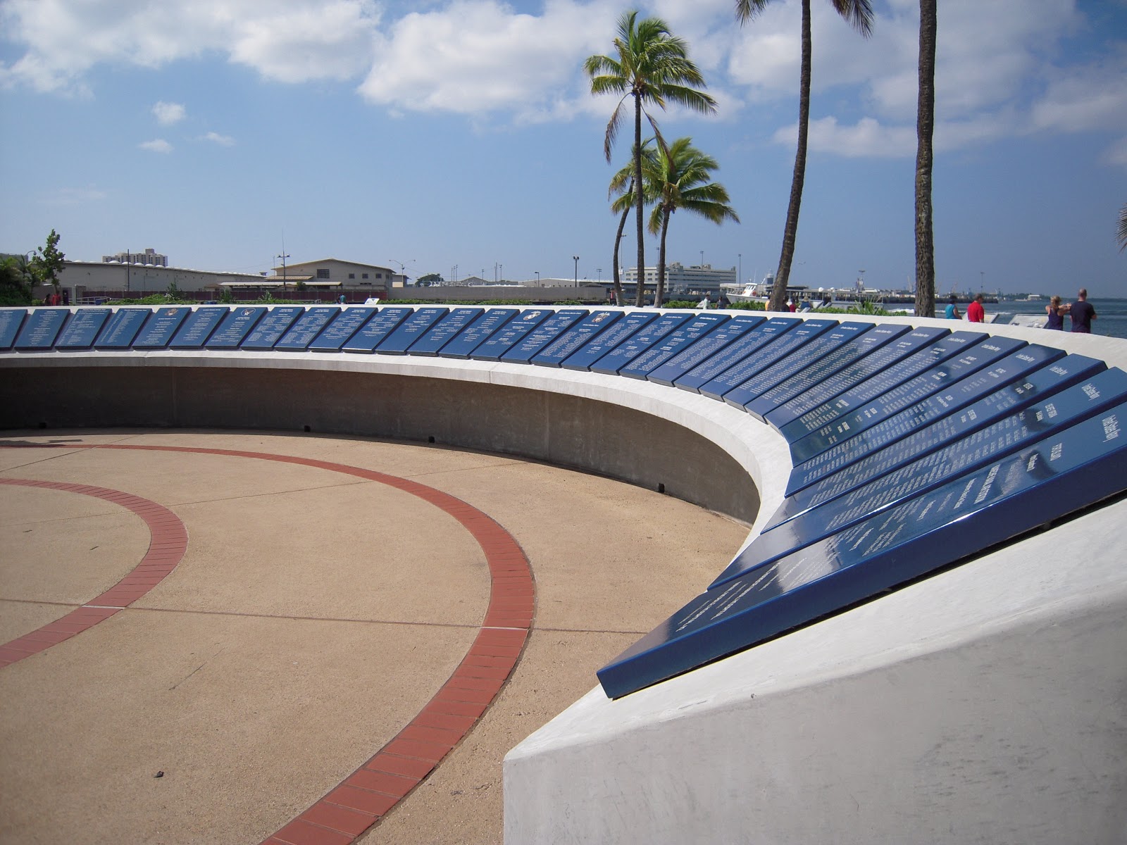
The WWII Valor in the Pacific National Monument was renovated and rededicated just three years ago.  The grounds are a living museum to the events of December 7th.  The monument is anchored by three historic vessels:  the remains of the battleship USS Arizona, the submarine USS Bowfin, and the battleship USS Missouri.  They represent respectively:  the attack that began the war, the war that avenged the attack, and the surrender that ended the war.  Two indoor exhibits tell the stories of the lead up to war, and the war effort.  A widescreen theater movie tells the story of the day.  A wall of remembrance is dedicated to the 2,402 service members killed in action that day, and the ships and bases on which they served.


The USS Arizona Memorial sits above and astride the wreckage of the Arizona at the bottom of Pearl Harbor, some 900 of her crew still entombed within.


The ride out to the Memorial is a solemn 10 minutes.  The Memorial is overcrowded, but starkly beautiful and deeply moving.


From the bottom of the harbor to the top of the hill.  We finished our tour at Punchbowl Crater, high above Honolulu.  Those lost on December 7th, and many heroes more, are honored and remembered at the National Memorial Cemetery of the Pacific.  It is Arlington West on a grand scale with a great view, 34,000 graves, the lives lost in the Pacific fighting World War II, and the conflicts in Korea and Vietnam.  A moment of silence, the offer of peace, for those who are here, and those we hope never will be.

We wasted the afternoon and early evening devoted to our own pursuits:  walking, shopping, seeking out the best Hawaiian Plate Lunch, mai tais at sunset on Waikiki.

We met back up, joined by the ultimate Northwest Expatriate turned Hawaiian Insider, Justin, for a late dinner at Alan Wong's eponymous restaurant.


Zagat gives it high praise, and the top food score in the city.  "The place where “Hawaii Regional cuisine was born and still reigns”, Alan Wong’s longtime McCully standout garners Oahu’s No. 1 Most Popular honors thanks to “inspired” cuisine, an “exceptional” wine list and “gracious” service that make it a “must when in Honolulu” for many, including President Obama; though some find the space otherwise “pedestrian” and the location “hard to find”, most agree the “heavenly experience” is “well worth the effort” and “pricey” tabs."

The chef himself promises "Hawaii Regional Cuisine at its finest — a menu inspired by the diverse ethnic cultures found in Hawaii and by the freshly farmed ingredients from our islands."

Many star chef restaurants fail to live up to the hype consistently from visit to visit and course to course, but we came here to “Taste Hawaii!," and this is the place.

There was not a single disappointment, every bite an inspired creation perfectly executed.  The signature onaga was crusted crispy and aromatic, lush and lovely within, creamy corn and mushrooms providing pop and circumstance below.  This dish first among equals, the rest was just as good.  This was the best meal of the trip, and we don't need the next three weeks to prove it.

Alan Wong's Menu:

“Soup And Sandwich”
Chilled Vine Ripened Hamakua Springs Tomato Soup Grilled Mozzarella Cheese, Kalua Pig, & Foie Gras Sandwich

Chopped Ahi Sashimi
Wrapped in a Crispy Won Ton Purse, Avocado, Spicy Aioli and Wasabi Soy

Kona Lobster Dumplings
Chili, Garlic, Lemongrass, Black Bean Veloute

Nori Wrapped Tempura Ahi
Tomato Ginger Relish, Soy Mustard Sauce

Seafood “Lasagne”
Poached Lobster Tail, Mushrooms, Herb Oil

“H.R.C.aesar Salad," Crispy Parmesan Cheese Basket
Baby Maui Romaine Lettuce, Creamy Anchovy Dressing, Kalua Pig, Lomi Tomato Relish

Ginger Crusted Onaga, Long-Tail Red Snapper
Miso Sesame Vinaigrette, Organic Hamakua Mushroom & Corn

Twice Cooked Short Rib, Soy Braised and Grilled “Kalbi” Style
Gingered Shrimp, Ko Choo Jang Sauce

“Mini Coconut”
Haupia Sorbet in a Chocolate Shell, Tropical Fruits and Lilikoi Sauce

Waialua Chocolate “Crunch Bars”
Layers of Milk Chocolate Macadamia Nut Crunch and Bittersweet Chocolate Mousse


Thursday, October 11th
South Pacific
Day 12
ms Westerdam
Honolulu, Oahu, Hawaii
Aloha Tower Marketplace
Departing:  5:00 PM
Partly Cloudy - 78 Degrees

We are getting out of the city today, for a tour of island life au' natural.  On the way, we hit Waikiki, where very little is local and virtually nothing is natural.  Kalakaua Avenue is the Rodeo Drive of the Pacific.  The shops are European, the money is Japanese.  Even the sand is imported.

Diamond Head is holy high ground, a burial site, a navigational landmark, a former military installation, and a public park.  Diamond Head is the hot girl of Honolulu, nice to look at, but ugly and empty on the inside.

Hanauma Nature Preserve is all natural, but the Preserve is at risk.  3,000 people a day come to swim in the calm waters of the sheltered bay, snorkel over the coral growing just off shore, sit in the soft sand, and look up at the cliffs that frame the view on more than three sides.


Just up the coast, we came to Halona Cove and the Halona Blowhole.  The Cove is the secluded pocket beach that inspired romance in the lovers "From Here to Eternity."  The Blowhole is more power than passion.  As the surf surges into shore, a lava tube traps the water and channels the rush in and up, accelerating through the black rock, until it thunders out the top of the tube in an explosion of foam and spray.  It is something to behold.  We're told.  But today, the Blowhole Show is a no go.  All burp, and no boom.  Still, a beautiful place.


The drive along this side of the island is Oahu's finest, twists and turns, ups and downs, expansive views out to the water and vertical looks up the cliffs.  Makapuu Point is the Eastern tip of the island, where a lighthouse clings to its perch on the rocks.  North of the Point, hang-gliders leap from the cliffs above aiming for the beach below.  Seabird sanctuaries on Manana and Kaohikaipu islands are just offshore.


Our last, and longest, stop on the coast was Kaiona Beach Park, another landing spot for hang-gliders.  Sadly, some who fly with the birds are destined to swim with the fishes.  So it was for the man remembered at a funeral in the park today.  Aloha, friend.  Life's a beach.

Turning inland, and inward, our tour continued on sacred ground.  Polynesian polytheism was traditionally practiced on vast temple plateaus of limestone, each stone quarried, carried, and placed by hand.  These "Heiaus" were both spiritual and civic, gathering places for all things communal.  Ulupo Heiau dates from 500 A.D.  Now it is just a pile of rocks, the detail and the meaning lost to time, but sacred is forever.


The Pali cliffs of the Koolau Mountains bisect the island, dividing windward from leeward, wet from dry, 18 miles of vertical ridges and ravines, each one a windward waterfall in the rain.  The Pali Highway cuts a pass through the cliffs and emerges at the Pali lookout, a windy panorama of the Windward Coast from an elevation of 1,200 feet.  It is said, that it was said by Mark Twain to be "the most beautiful place on Earth."


Interesting note of the day:  Trees in Hawaii don't have rings.  Rings are caused by the variations in growth from season to season.  There are no seasons here.  It's growing season all year long.  Hawaiians have to use carbon dating to judge the age of their trees.  Fascinating!!!

Back in Honolulu, Justin had a recommendation for lunch.  He joined us at Nico's Pier 38, an open air seafood stand on the working waterfront.  It's in fancy new digs now, but it started in a shed on the pier, serving the daily catch to daily catchers.  It's that fresh, and they make a damn fine Plate Lunch too.

At sailaway just shy of sunset, the Aloha Tower bid us farewell as the "Shining City on the Beach" justified and solidified our changing view of Honolulu, gateway to paradise and major metropolis.  Downtown, Waikiki, Diamond Head.  Aloha.


Next Stop:  Hilo, Hawaii

Tuesday, October 9, 2012

Maui


Tuesday, October 9th
South Pacific
Day 10
ms Westerdam
Lahaina, Maui, Hawaii
Arriving:  10:00 AM
Departing:  11:00 PM
Partly Cloudy - 78 Degrees

Aloha!!!

After four long, but happy days at sea, we have finally arrived in the Hawaiian Islands, and Maui no ka 'oi - Maui is the best!!!  It is the "Valley Isle," the second-largest, and third-most populous, island of the Hawaiian Archipelago.

Maui is not to be done in a day.  It takes time for Maui to work its magic, to ease your life, slow your heart, calm your thoughts.  But we only have today.

The VOG lingered (Volcanic Originated Gas), the day not yet what it would become, when Westerdam anchored off the dry, leeward, West coast of Maui at Lahaina this morning.


King Kamehameha the Great united rule of the Hawaiian islands in 1810 and established Lahaina as the seat of the throne.  It was the homeport of the Pacific whaling fleet, reaching a peak of more than 400 ships in the 1840s.  Herman Melville worked the whaling ships, and jumped ship to stay in Lahaina, the inspiration for Moby Dick.  By the 1860s, sugarcane started to surpass whaling as the dominant industry.  By the 1960s, sugarcane gave way to tourism.  And here we are.

We spent the afternoon up the coast from Lahaina in Ka'anapali, a mile-long arc of spectacular public beach, and luxe private resorts.

We started at Whalers Village in the heart of Ka'anipali, an open-air mall Hawaiian style, and lunch at the Hula Grill, where cement meets sand under thatched roofs and tiki torches with live music and views of the water.  It was an authentic tourist lunch of mai tais, pupus, and locally-sourced meats and fish.


A landscaped walk runs the length of the beach fronting the resorts.  We walked North to the end and the sprawling Sheraton that climbs the rocks.  We toured the hotel, walked in the sand, and dipped toes in the water.  The shade of the Beachwalk was all but gone and the sun intense for the walk back down the beach.


Back in Lahaina, we took a walk down Front Street.  It still has the look of an 1840s whaling village, with a ramshackle grittiness that lends a little local authenticity to the upscale boutiques and art galleries, bars and chain restaurants, curio and T-shirt shops, but the best of Front Street is the view to the water from the spaces in between.


Still hot and humid in the late afternoon, we sat in plastic chairs in front of a street-side jewelry stand, and had a shave ice.  Ululani's Hawaiian Shave Ice is the best on Maui, and if you've never had the real thing, you have no idea.  This isn't crushed ice, it's soft as first snow.  The small is huge, the large must be the size of your head.  We had extra smalls.  Ice cream lines the bottom of the cup, a soft landing for the fluffy snow shaved from a single block of ice.  It's trimmed, compacted, molded, perfected.  Holes are drilled through to the bottom and then this soft white snowball of love is saturated in sweet, fruity, vibrant color.  Dozens of flavors, hundreds of combinations, a rainbow in your cup.  It starts with a spoon and ends in a straw, and it is so good.


Back to the ship for a rest and a shower, and then back into Lahaina for a late dinner.  The Lahaina Grill is by far the nicest room in town, and the iconic locally-inspired cuisine has earned the highest island food score in Zagat.  Signature dishes, and our favorites of the evening, include a trio of seafood cakes called "The Cake Walk," and a Kona coffee crusted rack of lamb.


The last tender back to the ship leaves at 10:30.  On the dock at 10:00, they pulled up gangway behind us.

Next Stop:  Honolulu, Oahu, Hawaii

The Hawaiian Islands


The Hawaiian Archipelago extends 1,500 miles and is comprised of 132 islands, atolls, and other formations, the largest of which are the eight major inhabited islands:

Hawaii
Maui
Oahu
Kauai
Molokai
Lanai
Niihau
Kahoolawe


We will be calling at Maui, Oahu, and Hawaii over the next four days.

Monday, October 8, 2012

Pacific Crossing


Friday, October 5th
South Pacific
Day 6
ms Westerdam
At Sea
Cloudy - 62 Degrees

Saturday, October 6th
South Pacific
Day 7
ms Westerdam
At Sea
Partly Cloudy - 68 Degrees

Sunday, October 7th
South Pacific
Day 8
ms Westerdam
At Sea
Mostly Sunny - 68 Degrees
HAPPY BIRTHDAY NANCY!!!

Monday, October 8th
South Pacific
Day 9
ms Westerdam
At Sea
Mostly Sunny - 73 Degrees

The Pacific Ocean is the largest body of water in the world, almost 65 million square miles from the Arctic to the Antarctic and Asia / Australia to the Americas, covering one-third of the surface of the Earth, and nearly 50% of its water surface.

It has been a smooth and easy Pacific Crossing, South-by-SouthWest from San Diego to the Hawaiian Islands, the seas mostly calm, the skies mostly sunny.  The sun has risen and set from stern to bow, off our Port-Side verandahs, leaving us awash in light from dawn 'til dusk.  Sunrise over water is a joy uncommon on the West Coast of the Mainland.


Wind and waves have been low, but swells have been high.  Waves are generated locally in concert with prevailing weather conditions.  Swells are generated far away by major weather disturbances.  Ships can cut through waves, but swells can cause problems.  These swells are from Alaska and they are slowing our progress.  We will have to make up time to get to Lahaina as scheduled.

In these conditions, the water is like molten glass.  It looks blue gel viscous.  There is almost no texture to it all.  The ship appears to be standing still with nothing against which to measure our speed.

We have continued our exercise regimens:  miles around deck and laps around the pool.  Ted and Tres make daily pilgrimages to the Hydropool & Thermal Suites.

Dr. Jack Hardy, Professor Emeritus of Western Washington University, has expanded our knowledge of the seas, lecturing on:

"The Tropical Pacific:  Oceanography & Marine Ecology"
"Daredevils: Underwater Longer & Deeper"
"The Amazing Coral Reef"
"Pirates: Ancient Egypt to Modern Somalia"

The ship gets ESPN via satellite (intermittently), so we were able to watch the Washington / Oregon game.  What an epic disaster.  It couldn't possibly have been worse.  Not a game-changer.

We celebrated Nancy's birthday in style Sunday night with two happy hours and dinner at the Pinnacle Grill.  In her honor, we poured Little Black Dress merlot.  It was a party!!!

2,200 nautical miles of open ocean behind us, the islands of Hawaii in front of us, we are looking forward Maui in the morning.  Aloha.

Next Stop:  Lahaina, Maui, Hawaii